Community Engagement
Navigate The Page
Virtual Engagement
To engage a wide audience, a hybrid outreach approach was employed, combining both in-person and virtual opportunities for input. A dedicated project website was developed providing a variety of virtual engagement tools that enabled the project to effectively connect with residents and reach a broader, more diverse demographic. Partnering agencies promoted the website using simple web addresses, links, and QR codes, which were shared through multiple channels, including A-frame signs placed in parks and public facilities; printed and digital flyers distributed to local businesses, HOAs, and schools; and other creative methods to encourage participation. A strong social media presence also played a critical role in successfully promoting the project. By creating relevant content and leveraging the social media platforms of MAG and project partners, the project’s reach and awareness were greatly expanded and enhanced.
The project website served as the central hub for all study-related information and public-engagement activities. The website provided community members with access to project background information, study objectives, partner agency information, project schedules, announcements, outreach opportunities, and engagement tools. As the primary source of project information, the website helped establish a consistent project identity while providing transparency throughout the planning process. It also created a convenient platform where users could stay informed about project progress, review study materials, and participate in various engagement activities regardless of location or schedule. The website played a critical role in expanding outreach beyond traditional public meetings and allowed the project team to engage a broader and more diverse audience throughout the region.
Interactive Website Tools
Click the link to see the results from the interactive tools.
Online Community Survey
An online survey was developed to gather detailed information regarding trail usage patterns, community priorities, desired improvements, mobility needs, and future investment preferences. The survey provided critical data that helped validate themes emerging from stakeholder meetings and public outreach events.
Interactive Mapping Platform
A web-based mapping application, Public Coordinate, allowed users to provide geographically specific feedback directly within the study corridor. Participants could identify barriers, gaps, safety concerns, missing connections, opportunity areas, destination locations, and desired future improvements by placing comments directly on an interactive map. This tool enabled the project team to better understand location-specific issues and opportunities throughout the approximately 90-mile corridor. The spatial nature of the feedback helped inform future corridor alignments, crossing improvements, and capital project recommendations.
Public Coordinate Map Feedback
Budget Prioritization Tool
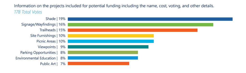
To better understand community priorities and preferences, the project website included an interactive budget allocation exercise that allowed participants to distribute a hypothetical budget among a range of potential trail and corridor improvements. Users were asked to evaluate competing investment categories and determine which improvements offered the greatest value to them. This exercise helped the project team understand how residents prioritized funding investments and provided valuable insight into which improvements should receive the greatest emphasis in future implementation phases. The results consistently reinforced the community’s desire for investments focused on connectivity, safety, comfort, and enhanced user experiences.
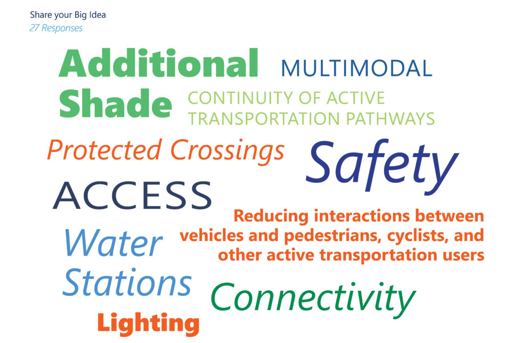
“Share Your Big Idea” Forum
Recognizing that community members often have creative ideas that extend beyond traditional planning questions, the project included a “Share Your Big Idea” forum where participants could submit open-ended suggestions and visionary concepts for the future of the corridor. This engagement tool encouraged innovation and allowed residents to identify opportunities that may not have been captured through surveys or other structured outreach methods. The forum generated valuable community-driven concepts that helped inform the study’s long-term vision and highlighted emerging priorities that consistently echoed throughout the broader engagement process.
Benefits of the Digital Engagement Program
Together, these digital engagement tools created a flexible and inclusive participation process that expanded the reach of the study and provided multiple ways for the public to contribute. Online engagement helped remove barriers associated with attending in-person meetings, increased accessibility for residents throughout the corridor, and allowed participants to provide input on their own schedule. The combination of surveys, mapping exercises, prioritization activities, and open-ended idea generation produced a robust dataset that complemented stakeholder discussions and public outreach events. This multi-faceted approach helped ensure that project recommendations were informed by a diverse range of community perspectives and accurately reflected regional priorities related to connectivity, safety, recreation, environmental stewardship, economic opportunity, and quality of life.