
Our Mission
Get to know the project. Learn how this impacts your community and the benefits you will experience from its development.
Page Sections:
Regional Transportation Context
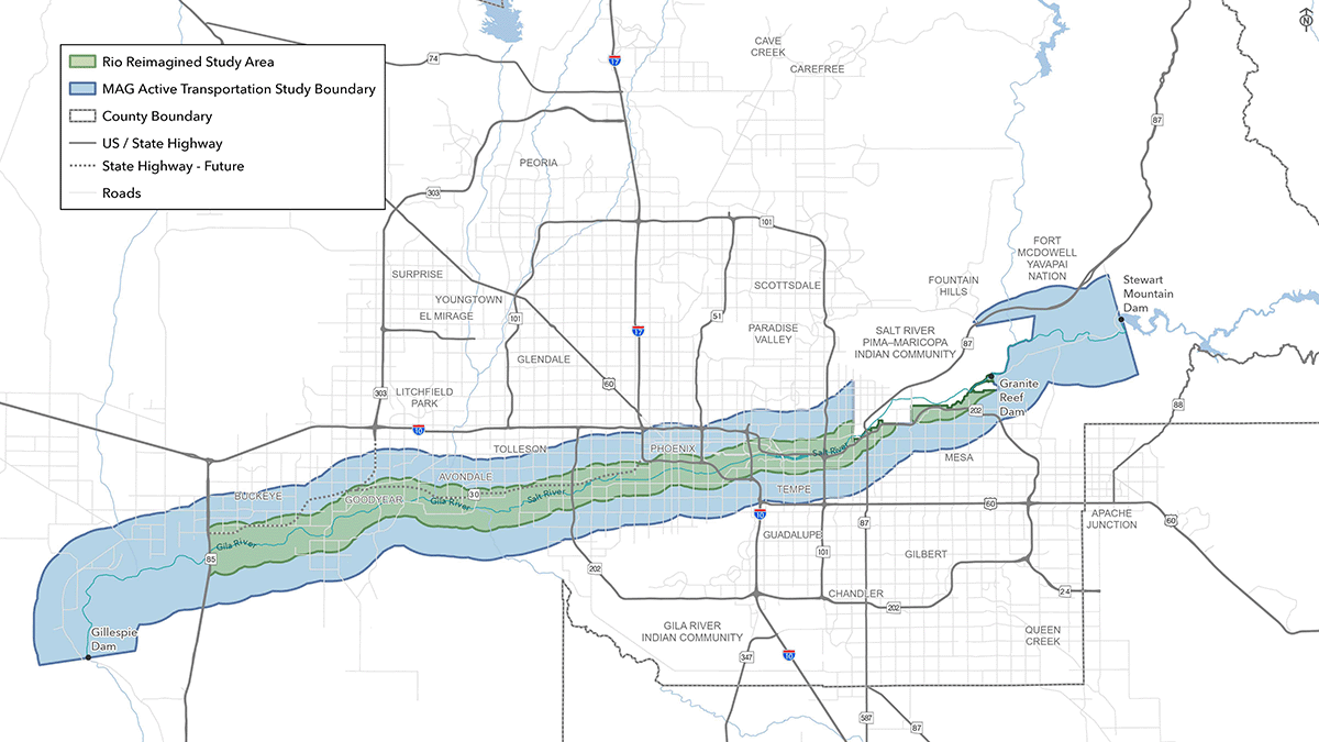
The Rio Reimagined corridor is connected to an extensive network of regional trails that provide access to communities, employment centers, recreational destinations, parks, and open space areas throughout Maricopa County. Among the most significant of these connections are the Sun Circle Trail and Maricopa Trail, two regional trail systems that intersect the study area at multiple locations and function as a highly interconnected network spanningmuch of The Valley.
Transit System
The Sun Circle Trail
The Sun Circle Trail in the West Valley, enters the study area from the north along Avondale Boulevard in Avondale and extends south to the Monument Hill Trailhead near the Base and Meridian Wildlife Area. At this location, the Sun Circle Trail connects with the Maricopa Trail before continuing east along portions of the Salt River corridor through Phoenix. The trail provides access to destinations including the Tres Rios Wetlands and continues southeast toward South Mountain Park and Preserve. Beyond the study area, the Sun Circle Trail continues east through Tempe, Chandler, and Gilbert before connecting with the Consolidated Canal Trail. The Consolidated Canal Trail extends north into and through Mesa and connects with the South Canal Trail, which continues northeast toward Granite Reef Dam. Within the study area, a proposed trailhead near Thomas Road and Higley Road would further strengthen access to this regional trail network.
The Maricopa Trail
The Maricopa Trail is another major regional trail system that provides important connections to the Rio Reimagined corridor. In the western portion of the study area, the trail traverses Buckeye and Goodyear south of the Salt River corridor, with access provided near proposed trailheads at Miller Road, Rainbow Road, and Jackrabbit Trail/Tuthill Road. Additional access is available through the Dove Trailhead in Buckeye Hills Regional Park, the Westar Hill Trailhead in Goodyear, and several trailheads within Estrella Mountain Regional Park. The trail continues east through the Estrella Foothills area before connecting with the Sun Circle Trail at Monument Hill near the Base and Meridian Wildlife Area. Another segment of the Maricopa Trail travels north-south through Goodyear, crossing the corridor at Estrella Parkway and connecting to the existing trailhead at the El Rio Research Project Site.
Connectivity
While the Sun Circle Trail and Maricopa Trail are distinct trail systems, they share a common alignment across a substantial portion of the Valley. From the Monument Hill area, the combined trail network provides connections to South Mountain, Tempe, Chandler, Gilbert, the Salt River Pima-Maricopa Indian Community, and Granite Reef Dam. Near Granite Reef Dam, the Maricopa Trail branches eastward to provide access to Usery Mountain Regional Park, one of the region’s premier recreational destinations. Beyond its connections to the study area, the Maricopa Trail continues throughout the Valley, traversing Scottsdale, Phoenix, Glendale, and numerous other communities before reconnecting with western portions of the regional trail network.
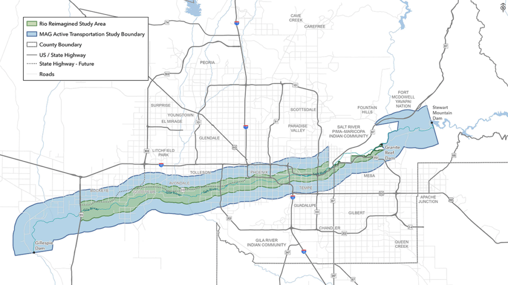
Caption to Map
In addition to these regional trail systems, the Rio Reimagined corridor also has opportunities to connect with the Valley’s extensive canal trail network. Existing and planned connections to facilities such as the Consolidated Canal Trail, South Canal Trail, and other canal-based shared use paths can further expand access to the corridor while providing important north-south and east-west connections throughout the metropolitan area. These facilities help link the corridor to surrounding communities, activity centers, and recreational destinations beyond the Rio corridor itself.
Similarities and Connection
While the Sun Circle Trail and Maricopa Trail are distinct trail systems, they share a common alignment across a substantial portion of the Valley. From the Monument Hill area, the combined trail network provides connections to South Mountain, Tempe, Chandler, Gilbert, the Salt River Pima-Maricopa Indian Community, and Granite Reef Dam. Near Granite Reef Dam, the Maricopa Trail branches eastward to provide access to Usery Mountain Regional Park, one of the region’s premier recreational destinations. Beyond its connections to the study area, the Maricopa Trail continues throughout the Valley, traversing Scottsdale, Phoenix, Glendale, and numerous other communities before reconnecting with western portions of the regional trail network.
In addition to these regional trail systems, the Rio Reimagined corridor also has opportunities to connect with the Valley’s extensive canal trail network. Existing and planned connections to facilities such as the Consolidated Canal Trail, South Canal Trail, and other canal-based shared use paths can further expand access to the corridor while providing important north-south and east-west connections throughout the metropolitan area. These facilities help link the corridor to surrounding communities, activity centers, and recreational destinations
beyond the Rio corridor itself.
Regional Active Transportation
The Rio Reimagined corridor presents a unique opportunity to strengthen regional active transportation connectivity by serving as an east-west spine through portions of the Valley that are not directly served by the Sun Circle Trail or Maricopa Trail. While these regional trail systems provide extensive connections around much of the metropolitan area, the Rio corridor follows an alignment through some of the region’s most populated and economically significant areas. The corridor has the potential to connect residential neighborhoods, employment centers, educational institutions, entertainment districts, recreational destinations, and cultural resources across multiple jurisdictions while supporting both recreational
and everyday trips.
Graphic Caption
Regional Network
The roadway network across the study area is expansive and includes freeways, arterials, and collectors. Freeway and arterial roadways account for nearly all crossings of the Rio Corridor today and provide critical mobility linkages for people driving, biking, and walking. The higher volumes of traffic on arterial corridors provide two key benefits:
Access
Crossings provide opportunities for major trailheads with parking and other amenities allowing visitors to drive and comfortably access river amenities. These trailheads also serve as destinations for bicycle and pedestrian travel from the surrounding network and allow communities to focus resources on providing safe and comfortable access to trailheads.
Visibility
The use of branding elements and gateways at arterial crossings raises the visibility of the Rio Corridor to people passing by helping to raise the profile and identity of the corridor and increase interest and awareness to river amenities.
Comfort Through Accessibility
Collector roadways have less traffic than arterials and typically provide access to neighborhood areas making them ideal opportunities for neighborhood-focused connections to river amenities, including secondary trailheads and access points. Collector roadways also serve as ideal bicycle and pedestrian routes between neighborhood areas and the Rio Corridor given their lower volumCollector roadways have less traffic than arterials and typically provide access to neighborhood areas making them ideal opportunities for neighborhood-focused connections to river amenities, including secondary trailheads and access points. Collector roadways also serve as ideal bicycle and pedestrian routes between neighborhood areas and the Rio Corridor given their lower volumes and lower speeds of traffic. Protected and buffered bike lanes, or shared use paths, provide safer and more comfortable routes.es and lower speeds of traffic. Protected and buffered bike lanes, or shared use paths, provide safer and more comfortable routes.
The West Valley’s roadway network is not yet built out, providing an ideal opportunity to integrate trailheads and safe, comfortable bicycle and pedestrian access to those trailheads, as development continues and roadways are built out. In contrast, the East Valley’s roadway network is nearly built out which will require roadway retrofits for safer bicycle and pedestrian connections to Rio Corridor amenities. Focusing on improving corridors and connections with the greatest potential benefit will help allocate resources towards linkages that provide the greatest potential benefit initially.
Transit
Transit service is provided by Valley Metro throughout the Rio Reimagined study area, creating opportunities to access the river corridor and its destinations. A network of local bus routes crosses the corridor, connecting surrounding communities to the corridor and to other transit services, including light rail, streetcar, and proposed bus rapid transit (BRT). Several Valley Metro Light Rail stations, Tempe Streetcar stops, and planned BRT investments provide important links between the corridor, surrounding communities, and the broader regional transit network.
Several light rail stations are located near the corridor and serve as key access points to the trail system and surrounding destinations:
Provides direct access to the existing trail alignment within the City of Phoenix and is adjacent to the Nina Mason Pulliam Audubon Center. Planned trail improvements and transit-oriented development surrounding the station will increase the number of destinations accessible from the corridor while supporting higher levels of pedestrian and bicycle activity within this section of Phoenix.

Is located just north of Tempe Town Lake and provides convenient access to the north bank Rio Salado Trail, along with numerous recreational destinations along the lake’s north shore. The station serves an already well-developed segment of the Rio Reimagined corridor. In addition, its proximity to the Tempe Town Lake Pedestrian Bridge provides convenient access to the south side of the lake, where a variety of trail- and shared-use path-oriented destinations are also located.
Is located south of Tempe Town Lake near Mill Avenue, providing convenient access to a wide variety of dining, entertainment, and recreational destinations. The south bank of Tempe Town Lake is also home to Tempe Center for the Arts, Tempe Beach Park, Rio Salado Park, and numerous other destinations. The station offers convenient access to these amenities and is located near the Tempe Town Lake Pedestrian Bridge, providing a direct connection to the north bank trail and its recreational destinations.
The Tempe Streetcar
further enhances local connectivity within the Tempe portion of the Rio Reimagined study area. Multiple streetcar stops along Rio Salado Parkway provide convenient connections between the corridor, Downtown Tempe, Arizona State University, employment centers, and surrounding activity centers. Together, the light rail and streetcar systems strengthen transit access to destinations adjacent to the corridor and expand access to
the regional trail network.
Looking Ahead
Together, existing and planned transit investments provide opportunities to improve access to the Rio Reimagined corridor from communities throughout the region. Future transit projects, including the City of Phoenix’s planned BRT corridor and the Scottsdale Road/Rural Road BRT corridor programmed in MAG’s Regional Strategic Transportation Infrastructure Investment Plan (RSTIIP), will further expand regional connectivity and create additional opportunities to reach corridor destinations. The Phoenix BRT corridor will connect with light rail at Greg Stanton Central Station in Downtown Phoenix, providing a transfer opportunity to the B Line for those traveling from areas west and northwest of Downtown Phoenix. The Scottsdale Road/Rural Road BRT corridor will strengthen north-south transit connectivity to the corridor, improving access from major destinations and activity centers including Old Town Scottsdale, Arizona State University, South Tempe, and the Chandler Fashion Center area.
While these future BRT investments will not directly serve all portions of the Rio Reimagined corridor, they will strengthen regional transit connectivity and improve access to the corridor for users traveling from surrounding communities. Complementary improvements such as trail connections, sidewalks, bikeways, wayfinding, and enhanced street crossings can strengthen first-mile and last-mile connections between transit facilities and the corridor, supporting a more seamless and multimodal transportation network.
On-Street Bicycle Facilities
On-street bicycle facilities play an important role in connecting surrounding communities to the Rio corridor. Bicycle connections are essential to ensuring people can access the corridor without a vehicle. While the Rio corridor serves as a major east-west spine through the Valley, a network of north-south bicycle facilities provides critical connections from surrounding communities and destinations.
Numerous arterial roadways throughout the study area include bicycle facilities that intersect the Rio corridor and provide direct north-south access. Within the East Valley portion of the study area, bicycle corridors providing access include Recker Road, Higley Road, Greenfield Road, Val Vista Drive, Gilbert Road, Alma School Road, Dobson Road, McClintock Drive, Mill Avenue, 24th Street, 7th Street, Central Avenue, and 7th Avenue. These facilities connect communities in Mesa, Tempe, and Phoenix to the corridor while also linking users to various other destinations and
active transportation facilities.
Graphic Caption
Facility Access
In the West Valley portion of the study area, access to the corridor is provided by facilities along 35th Avenue, 51st Avenue, Bullard Avenue, Estrella Parkway, and Cotton Lane. These routes provide important connections between the corridor and surrounding communities in western Phoenix, Avondale, Goodyear, and Buckeye. While the number of north-south bicycle corridors intersecting the Rio corridor is more limited in the West Valley portion of the study area, these facilities serve as key access routes to existing and planned trail segments, trailheads, parks, and recreation destinations.
Image/map/graphic caption
Development and Growth
The distribution of bicycle facilities throughout the study area generally reflects existing development and growth patterns across the Valley. Communities in the East Valley are more developed and are served by a mature transportation network that includes numerous arterial bicycle facilities. In contrast, portions of the West Valley continue to experience substantial growth and development, with significant population increases projected through 2050. As the roadway network expands to accommodate future growth, opportunities will exist to strengthen bicycle connections between emerging areas and the Rio corridor.
State Route 30
SR 30 will be constructed in phases over approximately 20 years. The initial segment, extending from Loop 202 to 97th Avenue, is scheduled to begin construction in 2027. The final segment, between Loop 303 and SR 85, is anticipated to be completed by approximately 2046.
A Given the relatively short distance between the freeway corridor and the Rio Reimagined corridor, there will be numerous opportunities to create active transportation connections between the two trail systems. This plan identifies priority bicycle corridors that, when enhanced with All Ages and Abilities active transportation improvements, can provide safe, comfortable, and convenient connections between the SR 30 shared-use path and the Rio Reimagined Shared Use Path.
Project Gallery
Take a look at the progress made towards our mission for the project.
Image Accordion #1
Image Accordion Content Goes Here! Click edit button to change this text.
Image Accordion #2
Image Accordion Content Goes Here! Click edit button to change this text.
Image Accordion #3
Image Accordion Content Goes Here! Click edit button to change this text.
Image Accordion #4
Image Accordion Content Goes Here! Click edit button to change this text.
Benefit of Trails & Project Need
Across the country, metropolitan regions are making significant investments in regional trail systems because of their wide-ranging benefits. High-profile examples include Atlanta’s BeltLine, Houston’s Bayou Greenways, the San Francisco Bay Area Trail, and The Chuck Huckleberry Loop in Tucson. Planned and constructed over many years, these systems have become defining regional assets that have generated substantial economic, recreational, and community benefits.
Closer to home, Scottsdale’s Indian Bend Wash Greenbelt demonstrates the long-term value of an interconnected trail system, serving as a recreational amenity, transportation corridor, and catalyst for economic development. As communities throughout the region continue to expand and enhance their own trail and pathway networks, the Rio Reimagined Shared Use Path will play a critical role in connecting these systems. By linking communities to one another and to the natural and recreational resources along the Salt and Gila Rivers, the project will help create a more cohesive local and regional trail network.
The benefits of trails and pathways are extensive and well documented. Key benefits include:
Quality of Life
A well-connected trail network enhances quality of life by providing safe and accessible opportunities for walking, bicycling, and outdoor recreation while linking neighborhoods, schools, parks, employment centers, and commercial districts.
Connectivity
Trails and pathways connect neighborhoods, parks, schools, workplaces, shopping areas, cultural destinations, and recreational amenities. Increased connectivity promotes social, physical, and economic activity while helping create a more cohesive and accessible community.
Active Transportation
Provide safe and convenient alternatives to driving by creating dedicated routes for walking, bicycling, and other forms of non-motorized travel. By making active transportation more comfortable and accessible, trails can reduce vehicle trips, ease congestion, and contribute to improved air quality.
Health
Encourage regular physical activity by providing safe, convenient spaces for walking, running, bicycling, and other forms of exercise. Trails help improve cardiovascular health, reduce the risk of chronic disease, and support both physical and mental well-being for residents of all ages.
Environment
Provide environmental benefits by encouraging walking, bicycling, and other forms of active transportation, reducing vehicle miles traveled and associated greenhouse gas emissions. They support the preservation of open space and natural areas, and promote more sustainable land use patterns.
Development and Tourism
Create significant economic value by making communities more attractive places to live, work, and invest. Proximity to trails has been shown to support higher property values and contribute to long-term regional economic vitality.
Active Transporation Trends
Active Transportation is the movement of people through non-motorized forms of travel, typically referring to people walking, biking, and rolling. Communities across The Valley have been investing in active transportation as residents increasingly express interest in walking and biking for recreational and other trips. Over the past decade, electric bikes (e-bikes) have grown in popularity and are leading to even more trips completed by bicycle.
As interest in active transportation has grown, it’s even more important to design bicycle and pedestrian facilities to be safe and enjoyable. Focusing on safety for people walking and biking, particularly as it relates to interactions with motorized vehicles, inevitably leads to more enjoyable and comfortable experiences that encourage more people to walk and bike.
There are several important active transportation principles that should guide design of connections to amenities within the Rio Corridor, referred to later in this plan as Priority Bicycle Corridors.
As we design bicycle and pedestrian facilities, we want to create an experience that’s safe and comfortable for a wide spectrum of people, including children and seniors. This involves thinking about the number of vehicles, travel speeds, and number of vehicular lanes and what the experience of someone walking and biking might be on that roadway. The design process weighs these factors and attempts to mitigate safety issues and enhance user comfort through shared-use paths, protected bike lanes, and other intentional features. The goal is to reduce the “stress” that a person walking and biking feels as much as possible, and by doing so, we can encourage more people to walk and bike.

Incorporating bicycle separation techniques is a cornerstone of the All Ages and Abilities concept described previously and helps to create space and separation between people driving and those walking and biking. Separation can be included in several different ways, including buffers between drivers and cyclists, vertical separation using concrete curbs and other vertical elements, or by fully moving a cyclist to an adjacent shared-use path on the busiest and highest speed roadways. Bicycle separation and creating All Ages and Abilities connections between neighborhoods and the Rio Corridor should be prioritized on Priority Bicycle Corridors described in this plan.

- In some cases, bicycle travel on roadways with high volumes and speeds of vehicular traffic should be avoided, especially when nearby roadways can provide the same connection through a lower stress experience for the person biking. These alternative routes, called parallel routes, typically leverage collector roadways and neighborhood streets with far fewer vehicles and slower speeds to make important connections, still following All Ages and Abilities principles. Priority Bicycle Corridors described in this plan are focused on arterial roadways, but lower stress, parallel routes should be considered and preferred when they are able to offer the same connectivity benefits of linking neighborhood areas to Rio Corridor trails and amenities.
Heat exposure is becoming an increasingly critical component of bicycle and pedestrian facility design. In addition to making walking and biking safer by increasing separation between people driving and biking, shade and amenities also play a critical role in encouraging walking and biking. Shade can be provided through native trees and vegetation that can mitigate heat exposure, especially during warmer months. Shade sails and similar elements are also increasingly included in areas with higher volumes of pedestrians and cyclists.