
Our Mission
Get to know the project. Learn how this impacts your community and the benefits you will experience from its development.
Page Sections:
About the Study
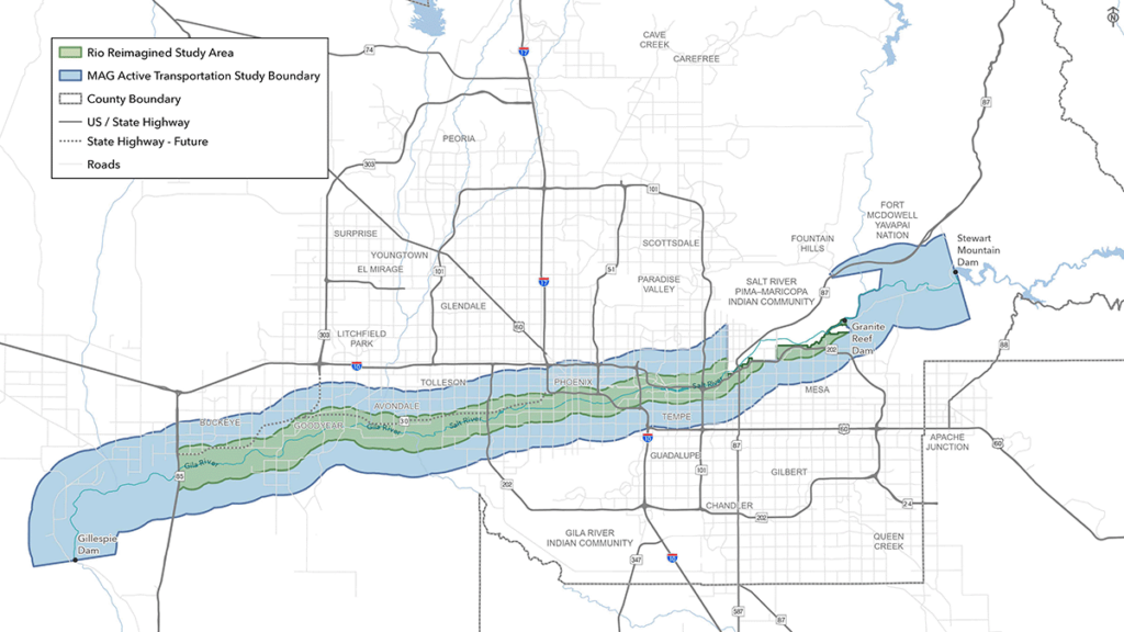
The Rio Reimagined corridor is connected to an extensive network of regional trails that provide access to communities, employment centers, recreational destinations, parks, and open space areas throughout Maricopa County. Among the most significant of these connections are the Sun Circle Trail and Maricopa Trail, two regional trail systems that intersect the study area at multiple locations and function as a highly interconnected network spanningmuch of The Valley.
The Sun Circle Trail
The Sun Circle Trail in the West Valley, enters the study area from the north along Avondale Boulevard in Avondale and extends south to the Monument Hill Trailhead near the Base and Meridian Wildlife Area. At this location, the Sun Circle Trail connects with the Maricopa Trail before continuing east along portions of the Salt River corridor through Phoenix. The trail provides access to destinations including the Tres Rios Wetlands and continues southeast toward South Mountain Park and Preserve. Beyond the study area, the Sun Circle Trail continues east through Tempe, Chandler, and Gilbert before connecting with the Consolidated Canal Trail. The Consolidated Canal Trail extends north into and through Mesa and connects with the South Canal Trail, which continues northeast toward Granite Reef Dam. Within the study area, a proposed trailhead near Thomas Road and Higley Road would further strengthen access to this regional trail network.
The Maricopa Trail
The Maricopa Trail is another major regional trail system that provides important connections to the Rio Reimagined corridor. In the western portion of the study area, the trail traverses Buckeye and Goodyear south of the Salt River corridor, with access provided near proposed trailheads at Miller Road, Rainbow Road, and Jackrabbit Trail/Tuthill Road. Additional access is available through the Dove Trailhead in Buckeye Hills Regional Park, the Westar Hill Trailhead in Goodyear, and several trailheads within Estrella Mountain Regional Park. The trail continues east through the Estrella Foothills area before connecting with the Sun Circle Trail at Monument Hill near the Base and Meridian Wildlife Area. Another segment of the Maricopa Trail travels north-south through Goodyear, crossing the corridor at Estrella Parkway and connecting to the existing trailhead at the El Rio Research Project Site.
Similarities and Connection
While the Sun Circle Trail and Maricopa Trail are distinct trail systems, they share a common alignment across a substantial portion of the Valley. From the Monument Hill area, the combined trail network provides connections to South Mountain, Tempe, Chandler, Gilbert, the Salt River Pima-Maricopa Indian Community, and Granite Reef Dam. Near Granite Reef Dam, the Maricopa Trail branches eastward to provide access to Usery Mountain Regional Park, one of the region’s premier recreational destinations. Beyond its connections to the study area, the Maricopa Trail continues throughout the Valley, traversing Scottsdale, Phoenix, Glendale, and numerous other communities before reconnecting with western portions of the regional trail network.
In addition to these regional trail systems, the Rio Reimagined corridor also has opportunities to connect with the Valley’s extensive canal trail network. Existing and planned connections to facilities such as the Consolidated Canal Trail, South Canal Trail, and other canal-based shared use paths can further expand access to the corridor while providing important north-south and east-west connections throughout the metropolitan area. These facilities help link the corridor to surrounding communities, activity centers, and recreational destinations
beyond the Rio corridor itself.
How They Connect
In addition to these regional trail systems, the Rio Reimagined corridor also has opportunities to connect with the Valley’s extensive canal trail network. Existing and planned connections to facilities such as the Consolidated Canal Trail, South Canal Trail, and other canal-based shared use paths can further expand access to the corridor while providing important north-south and east-west connections throughout the metropolitan area.
Beyond its connections to the study area, the Maricopa Trail continues throughout the Valley, traversing Scottsdale, Phoenix, Glendale, and numerous other communities before reconnecting with western portions of the regional trail network.
Regional Activity
The Rio Reimagined corridor presents a unique opportunity to strengthen regional active transportation connectivity by serving as an east-west spine through portions of the Valley that are not directly served by the Sun Circle Trail or Maricopa Trail. While these regional trail systems provide extensive connections around much of the metropolitan area, the Rio corridor follows an alignment through some of the region’s most populated and economically significant areas. The corridor has the potential to connect residential neighborhoods, employment centers, educational institutions, entertainment districts, recreational destinations, and cultural resources across multiple jurisdictions while supporting both recreational and everyday trips.


Your Benefits
The benefits of trails and pathways are extensive and well documented. Key benefits include:
Quality of Life
Lorem ipsum dolor sit amet, consectetur adipiscing elit. Ut elit tellus, luctus nec ullamcorper mattis, pulvinar dapibus leo.
Connectivity
Lorem ipsum dolor sit amet, consectetur adipiscing elit. Ut elit tellus, luctus nec ullamcorper mattis, pulvinar dapibus leo.
Active Transportation
Lorem ipsum dolor sit amet, consectetur adipiscing elit. Ut elit tellus, luctus nec ullamcorper mattis, pulvinar dapibus leo.
Similarities and Connection
While the Sun Circle Trail and Maricopa Trail are distinct trail systems, they share a common alignment across a substantial portion of the Valley. From the Monument Hill area, the combined trail network provides connections to South Mountain, Tempe, Chandler, Gilbert, the Salt River Pima-Maricopa Indian Community, and Granite Reef Dam. Near Granite Reef Dam, the Maricopa Trail branches eastward to provide access to Usery Mountain Regional Park, one of the region’s premier recreational destinations. Beyond its connections to the study area, the Maricopa Trail continues throughout the Valley, traversing Scottsdale, Phoenix, Glendale, and numerous other communities before reconnecting with western portions of the regional trail network.
In addition to these regional trail systems, the Rio Reimagined corridor also has opportunities to connect with the Valley’s extensive canal trail network. Existing and planned connections to facilities such as the Consolidated Canal Trail, South Canal Trail, and other canal-based shared use paths can further expand access to the corridor while providing important north-south and east-west connections throughout the metropolitan area. These facilities help link the corridor to surrounding communities, activity centers, and recreational destinations
beyond the Rio corridor itself.
Strengthening Connectivity
The Rio Reimagined corridor presents a unique opportunity to strengthen regional active transportation connectivity by serving as an east-west spine through portions of the Valley that are not directly served by the Sun Circle Trail or Maricopa Trail.
Key Principles
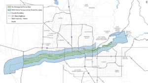
There are several important active transportation principles that should guide design of connections to amenities within the Rio Corridor, referred to later in this plan as Priority Bicycle Corridors.
As we design bicycle and pedestrian facilities, we want to create an experience that’s safe and comfortable for a wide spectrum of people, including children and seniors. This involves thinking about the number of vehicles, travel speeds, and number of vehicular lanes and what the experience of someone walking and biking might be on that roadway. The design process weighs these factors and attempts to mitigate safety issues and enhance user comfort through shared-use paths, protected bike lanes, and other intentional features. The goal is to reduce the “stress” that a person walking and biking feels as much as possible, and by doing so, we can encourage more people to walk and bike.
Incorporating bicycle separation techniques is a cornerstone of the All Ages and Abilities concept described previously and helps to create space and separation between people driving and those walking and biking. Separation can be included in several different ways, including buffers between drivers and cyclists, vertical separation using concrete curbs and other vertical elements, or by fully moving a cyclist to an adjacent shared-use path on the busiest and highest speed roadways. Bicycle separation and creating All Ages and Abilities connections between neighborhoods and the Rio Corridor should be prioritized on Priority Bicycle Corridors described in this plan
In some cases, bicycle travel on roadways with high volumes and speeds of vehicular traffic should be avoided, especially when nearby roadways can provide the same connection through a lower stress experience for the person biking. These alternative routes, called parallel routes, typically leverage collector roadways and neighborhood streets with far fewer vehicles and slower speeds to make important connections, still following All Ages and Abilities principles. Priority Bicycle Corridors described in this plan are focused on arterial roadways, but lower stress, parallel routes should be considered and preferred when they are able to offer the same connectivity benefits of linking neighborhood areas to Rio Corridor trails and amenities.
Heat exposure is becoming an increasingly critical component of bicycle and pedestrian facility design. In addition to making walking and biking safer by increasing separation between people driving and biking, shade and amenities also play a critical role in encouraging walking and biking. Shade can be provided through native trees and vegetation that can mitigate heat exposure, especially during warmer months. Shade sails and similar elements are also increasingly included in areas with higher volumes of pedestrians and cyclists.
Project Gallery
Take a look at the progress made towards our mission for the project.
Image Accordion #1
Image Accordion Content Goes Here! Click edit button to change this text.
Image Accordion #2
Image Accordion Content Goes Here! Click edit button to change this text.
Image Accordion #3
Image Accordion Content Goes Here! Click edit button to change this text.
Image Accordion #4
Image Accordion Content Goes Here! Click edit button to change this text.
Additional Links
Access more information and resources outside of this site.
Lorem ipsum dolor sit amet, consectetur adipiscing elit. Ut elit tellus, luctus nec ullamcorper mattis, pulvinar dapibus leo.