Participate
Help plan the future of active transportation along the river corridor. Your participation is critical to the success of this Active Transportation Study.
We Want to Hear From You!
You can get involved right now using the buttons below to:
Upcoming Community Workshops
May 19, 2026 | 4-7pm
Arizona State University
777 S Novus Pl
Tempe, AZ, 85281
May 20, 2026 | 4-7pm
Avondale Visitor & Conference Center
11490 W Civic Center Dr
Avondale, AZ, 85323
May 21, 2026 | 12-4pm
Nina Mason Pulliam Rio Salado Audubon Center
3131 S Central Ave
Phoenix, AZ, 85040
Outreach Pop-Up Event Summaries
The Rio Reimagined Active Transportation Study team hosted public outreach events in Phoenix, Goodyear, Tempe, and Buckeye. These events featured activities to gather public input on the future of the river corridor. Over 400 participants shared their opinions, with the results outlined in the PDF linked below.
Previous Participation Tools
Thank you for helping plan the future of active transportation along the river corridor.
Get Connected
Subscribe to our email list to stay connected. Your information will be kept confidential.
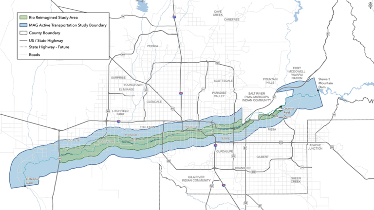
Purpose
This study will provide a coordinated vision of a multi-use path and connectivity across jurisdictions, recommending a river path alignment and connections that enhance the mobility and accessibility of people using active transportation modes within the study area.
- Corridor-wide Connectivity
- Community Connections
- Trail Alignment
- Understand Potential Partnership and Funding Options
- Create a Comprehensive Vision
- Project Coordination
- Prioritize Future Improvements
- Evaluate Operations and Maintenance Practices to Generate Long-Term Sustainability
FAQS
What is an Active Transportation Study?
A long-range plan that identifies key initiatives and implementation strategies to guide future active transportation projects over the next 10+ years. Active transportation is any form of human powered transportation and low speed electronic assist devices. Examples of active transportation include walking, running or utilizing bicycles, e-bicycles, wheelchairs, electric wheelchairs, scooters, e-scooters, skates and skateboards. Active transportation is a critical component of a successful multi-modal transportation network and assists in meeting environmental, recreation, economic, and equity goals.
How will the Active Transportation Study be utilized?
The plan will provide a roadmap for the agencies along the river corridor to prioritize projects and funding, develop and improve active transportation opportunities, and create a vision for the future. Strategic recommendations and short-, mid-, and long-term goals will be identified in the plan for each agency to work towards implementing.
How can I participate in the Active Transportation Study?
- See above to complete the online survey, comment on an interactive map, and more.
- Connect with us at community events.
- Contact us using the form below.
Contact Us
For more information please call Maricopa Association of Governments.
602-254-6300 | [email protected]
Click here for more information.